Copy and Delete Features, Dice, Feature Envelope to Polygon and Feature to Line Tools
Copy Features
How to Copy Features Tool in ArcToolbox ArcMap ArcGIS??
 |
| Copy Features |
Path to access the tool
:
Copy
Features Tool, Feature Toolset, Data Management
Tools Toolbox
Copy Features
Copies features from the input feature class or layer to a
new feature class. If the input is a layer which has a selection, only the
selected features will be copied. If the input is a geodatabase feature class
or shapefile, all features will be copied.
1. Input Features
The features to be
copied.
2. Output Feature Class
The feature class which
will be created and to which the features will be copied.
3. Configuration Keyword (optional)
Geodatabase
configuration keyword to be applied if the output is a geodatabase.
4. Output Spatial Grid 1 (optional)
The Output Spatial Grid
1, 2, and 3 parameters apply only to file geodatabases and certain enterprise
geodatabase feature classes. If you are unfamiliar with setting grid sizes,
leave these options as 0,0,0 and ArcGIS will compute optimal sizes for you. For
more information about this parameter, refer to the Add Spatial Index tool
documentation.
5. Output Spatial Grid 2 (optional)
Cell size of the second
spatial grid. Leave the size at 0 if you only want one grid. Otherwise, set the
size to at least three times larger than Output Spatial Grid 1.
6. Output Spatial Grid 3 (optional)
Cell size of the third
spatial grid. Leave the size at 0 if you only want two grids. Otherwise, set
the size to at least three times larger than Output Spatial Grid 2.
Delete Features
How to Delete Features Tool in ArcToolbox ArcMap ArcGIS??
 |
| Delete Features |
Path to access the tool
:
Delete
Features Tool, Feature Toolset, Data
Management Tools Toolbox
Delete Features
Deletes all or the
selected subset of features from the input.
If the input features
are from a feature class, all rows will be deleted. If the input features are
from a layer with no selection, all features will be deleted.
1. Input Features
The feature class,
shapefile, or layer containing features to be deleted.
Dice
How to Dice Tool in ArcToolbox ArcMap ArcGIS??
 |
| Dice Tool |
Path to access the tool
:
Dice Tool, Feature Toolset,
Data
Management Tools Toolbox
Dice
Subdivides a feature into smaller features based on a
specified vertex limit. This tool is intended as a way to subdivide extremely
large features that cause issues with drawing, analysis, editing, and/or performance
but are difficult to split up with standard editing and geoprocessing tools.
This tool should not be used in any cases other than those where tools are
failing to complete successfully due to the size of features.
1. Input Features
The input feature class
or feature layer. The geometry type must be multipoint, line, or polygon.
2. Output Feature Class
The output feature class of diced features.
3. Vertex Limit
Features with geometries
that exceed this vertex limit will be subdivided before being written to the output
feature class.
Feature Envelope to Polygon
How to Feature Envelope to Polygon Tool in ArcToolbox ArcMap ArcGIS??
 |
| Feature Envelope to Polygon |
Path to access the tool
:
Feature
Envelope to Polygon Tool, Feature Toolset, Data
Management Tools Toolbox
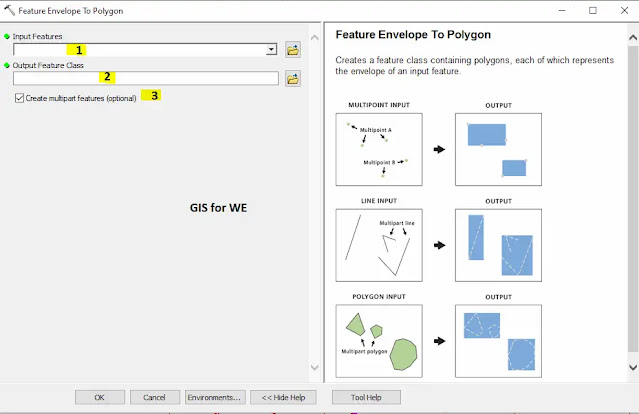
Feature Envelope to Polygon
Creates a feature class
containing polygons, each of which represents the envelope of an input feature.
1. Input Features
The input features that
can be multipoint, line, polygon, or annotation.
2. Output Feature Class
The output polygon
feature class.
3. Create multipart features (optional)
Specifies whether to use one envelope for each entire multipart feature or one envelope per part of a multipart feature. This parameter will affect the results of multipart input features only.
- Unchecked—Uses one envelope containing an entire multipart feature; therefore, the resulting polygon will be singlepart. This is the default.
- Checked—Uses one envelope for each part of a multipart feature; the resulting polygon of the multipart feature will remain multipart.
Feature to Line
How to Feature to Line Tool in ArcToolbox ArcMap ArcGIS??
 |
| Feature to Line |
Path to access the tool
:
Feature
to Line Tool, Feature Toolset, Data
Management Tools Toolbox
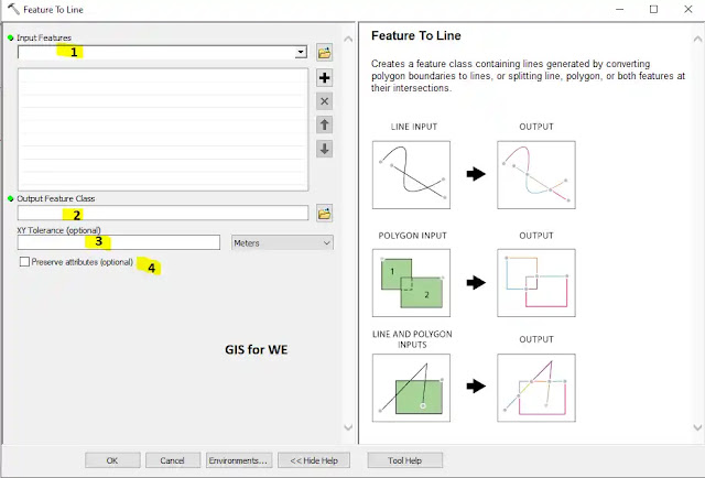
Feature to Line
1. Input Features
The input features that
can be line or polygon, or both.
2. Output Feature Class
The output line feature
class.
3. XY Tolerance (optional)
The minimum distance separating
all feature coordinates, and the distance a coordinate can move in X, Y, or
both during spatial computation. The default XY tolerance is set to 0.001 meter
or its equivalent in feature units.
4. Preserve attributes (optional)
Specifies whether to preserve or omit the input feature attributes in the output feature class.
- Checked—Preserves the input attributes in the output features. This is the default.
- Unchecked—Omits the input attributes in the output features.

Comments
Post a Comment