Frequency, Summary Statistics and Tabulate Intersection Tools
Frequency
How to use Frequency Tool in ArcToolbox ArcMap ArcGIS??
 |
| Frequency Tool |
Frequency Tool, Statistics Toolset, Analysis Toolbox
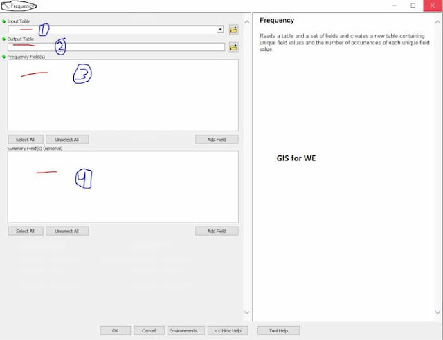
Frequency
Reads a table and a set
of fields and creates a new table containing unique field values and the number
of occurrences of each unique field value.
1. Input Table
The table containing the
field(s) that will be used to calculate frequency statistics.
2. Output Table
The output table that
will store the frequency statistics.
3. Frequency Field(s)
The field(s) used to
calculate frequency statistics. Each unique combination of field values will be
included as a new row in the output table.
4. Summary Field(s) (optional)
The attribute field(s)
to sum and add to the output table. Values will be summed for each unique
combination of frequency fields. Null values are excluded from this
calculation.
Summary Statistics
How to use Summary Statistics Tool in ArcToolbox ArcMap ArcGIS??
 |
| Summary Statistics Tool |
Summary Statistics Tool, Statistics Toolset, Analysis Toolbox
Summary Statistics
Calculates summary
statistics for field(s) in a table.
1. Input Table
The input table
containing the field(s) that will be used to calculate statistics. The input
can be an INFO table, a dBASE table, an OLE DB table, a VPF table, or a feature
class.
2. Output Table
The output dBASE or
geodatabase table that will store the calculated statistics.
3. Statistics Field(s)
The numeric field
containing attribute values used to calculate the specified statistic. Multiple
statistic and field combinations may be specified. Null values are excluded
from all statistical calculations.
Text attribute fields
can be summarized using first and last statistics. Numeric attribute fields can
be summarized using any statistic.
- Available statistics types are as follows:
- SUM—Adds the total value for the specified field.
- MEAN—Calculates the average for the specified field.
- MIN—Finds the smallest value for all records of the specified field.
- MAX—Finds the largest value for all records of the specified field.
- RANGE—Finds the range of values (maximum minus minimum) for the specified field.
- STD—Finds the standard deviation on values in the specified field.
- COUNT—Finds the number of values included in statistical calculations. This counts each value except null values. To determine the number of null values in a field, create a count on the field in question, create a count on a different field that does not contain null values (for example, the OID if present), and subtract the two values.
- FIRST—Finds the first record in the input and uses its specified field value.
- LAST—Finds the last record in the input and uses its specified field value.
4. Case field (optional)
The fields in the input used to calculate
statistics separately for each unique attribute value (or combination of
attribute values when multiple fields are specified).
Tabulate Intersection
How to use Tabulate Intersection Tool in ArcToolbox ArcMap ArcGIS??
 |
| Tabulate Intersection Tool |
Tabulate Intersection Tool, Statistics Toolset, Analysis Toolbox
Tabulate Intersection
Computes the
intersection between two feature classes and cross-tabulates the area, length,
or count of the intersecting features.
1. Input Zone Features
The features used to
identify zones.
2. Zone Fields
The attribute field or
fields that will be used to define zones.
3. Input Class Features
The features used to
identify classes.
4. Output Table
The table that will
contain the cross-tabulation of intersections between zones and classes.
5. Class Fields (optional)
The attribute field or
fields used to define classes.
6. Sum Fields (optional)
The fields to sum from
the Input Class Features.
7. XY Tolerance (optional)
The distance that
determines the range in which features or their vertices are considered equal.
By default, this is the XY Tolerance of the Input Zone Features.
8. Output Units (optional)
Units to be used to calculate area or length measurements. Setting Output Units when the Input Class Features are points is not supported.

Comments
Post a Comment