Polyline to Raster, Raster to Other Format and Feature Class to Shapefile Tools
Polyline to Raster
How to use Polyline to Raster Tool in ArcToolbox ArcMap ArcGIS??
 |
| Polyline to Raster |
Path to access the tool
:
Polyline
to Raster Tool, To Raster Toolset, Conversion Toolbox
Polyline to Raster
Converts polyline
features to a raster dataset.
1. Input Features
The polyline input
feature dataset to be converted to a raster.
2. Value field
The field used to assign
values to the output raster.
It can be any field of
the input feature dataset's attribute table.
3. Output Raster Dataset
The output raster
dataset to be created.
When not saving to a
geodatabase, specify .tif for a TIFF file format, .CRF for CRF file format,
.img for an ERDAS IMAGINE file format, or no extension for an Esri Grid raster
format.
4. Cell assignment type (optional)
The method to determine how the cell will be assigned a value when more than one feature falls within a cell.
- MAXIMUM_LENGTH—The feature with the longest length that covers the cell will determine the value to assign to the cell.
- MAXIMUM_COMBINED_LENGTH—If there is more than one feature in a cell with the same value, the lengths of these features will be combined. The combined feature with the longest length within the cell will determine the value to assign to the cell.
5. Priority field (optional)
This field is used to determine which feature should take
preference over another feature that falls over a cell. When it is used, the
feature with the largest positive priority is always selected for conversion
irrespective of the Cell assignment type chosen.
6. Cell size (optional)
The cell size for the output raster being created.
This parameter can be defined by a numeric value or obtained from
an existing raster dataset. If the cell size hasn’t been explicitly specified
as the parameter value, then the environment cell size value is used if
specified; otherwise some additional rules are used to calculate it from the
other inputs. See the usage for more detail.
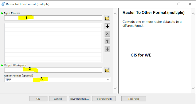
Raster to Other Format (multiple)
How to use Raster to Other Format (multiple) Tool in ArcToolbox ArcMap ArcGIS??
 |
| Raster to Other Format (multiple) |
Path to access the tool
:
Raster
to Other Format (multiple) Tool, To Raster Toolset,
Conversion Toolbox
Raster to Other Format (multiple)
Converts one or more
raster datasets to a different format.
1. Input Rasters
The raster datasets to
convert.
2. Output Workspace
The folder where the
raster dataset will be written.
3. Raster Format (optional)
The format of the new raster dataset.
- BIL—Esri Band Interleaved by Line file
- BIP—Esri Band Interleaved by Pixel file
- BMP—Microsoft bitmap graphic raster dataset format
- BSQ—Esri Band Sequential file
- CRF—Cloud Raster Format
- ENVI DAT—ENVI DAT file
- GIF—Graphic Interchange Format for raster datasets
- GRID—Esri Grid raster dataset format
- IMAGINE Image—ERDAS IMAGINE raster data format
- JP2000—JPEG 2000 raster dataset format
- JPEG—Joint Photographic Experts Group raster dataset format
- MRF—Meta Raster Format
- PNG—Portable Network Graphic raster dataset format
- TIFF—Tagged Image File Format for raster datasets
Feature Class to Shapefile (multiple)
How to use Feature Class to Shapefile (multiple) Tool in ArcToolbox ArcMap ArcGIS??
 |
| Feature Class to Shapefile (multiple) |
Path to access the tool
:
Feature
Class to Shapefile (multiple) Tool, To Shapefile Toolset,
Conversion Toolbox
Feature Class to Shapefile
(multiple)
Copies the features from
one or more feature classes or layers to a folder of shapefiles.
1. Input Features
The list of input
feature classes or feature layers that will be converted and added to the
output folder.
2. Output Folder
The folder where the shapefiles will be written.

Comments
Post a Comment