Stack Profile, Surface Volume
Stack Profile
How to use Stack Profile Tool in ArcToolbox ArcMap ArcGIS ??
 |
| Stack Profile |
Stack Profile Tool, Functional Surface Toolset, 3D Analyst Toolbox
Stack Profile
Creates a table and
optional graph denoting the profile of line features over one or more
multipatch, raster, TIN, or terrain surfaces.
1. Input Line Features
The line features that will be profiled over the surface inputs.
2. Profile Targets
The data being profiled, which can be comprised from any combination of multipatch features, raster, and triangulated surface models.
3. Output Table
The output table that will store the height interpolated for each profile target that intersects the input line.
4. Output Graph Name (optional)
The name of the output graph that can be viewed in ArcMap, ArcScene, or ArcGlobe.
Surface Volume
How to use Surface Volume Tool in ArcToolbox ArcMap ArcGIS ??
 |
| Surface Volume |
Surface Volume Tool, Functional Surface Toolset, 3D Analyst Toolbox
Surface Volume
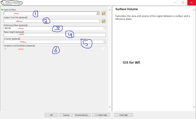
Calculates the area and volume of the region between a surface and a reference plane.
1. Input Surface
The raster, TIN, or terrain surface to process.
2. Output Text File (optional)
A comma-delimited ASCII
text file containing the area and volume calculations. If the file already
exists, the new results will be appended to the file.
3. Reference Plane (optional)
The direction from the
reference plane for which to calculate the results.
·
ABOVE—Volume and area calculations will represent the region of
space between the specified plane height and the portions of the surface that
are above the plane. This is the default.
·
BELOW—Volume and area calculations will represent the region of
space between the specified plane height and portions of the surface that are
below the plane.
4. Plane Height (optional)
The Z value of the plane that will be used to calculate area and volume.
5. Z Factor (optional)
The factor by which z-values will be multiplied. This is typically used to convert Z linear units to match XY linear units. The default is 1, which leaves elevation values unchanged. This parameter is disabled if the spatial reference of the input surface has a Z datum with a specified linear unit.
6. Pyramid Level Resolution (optional)
The z-tolerance or window-size resolution of the terrain pyramid level that will be used by this tool. The default is 0, or full resolution.

Comments
Post a Comment