Int, Minus, Plus and Times Tools
Int
How to use Int Tool in ArcToolbox ArcMap ArcGIS ??
 |
| Int Tool |
Int Tool, Raster Math Toolset, 3D Analyst Toolbox
Int
Converts each cell value
of a raster to an integer by truncation.
1. Input raster or constant value
The input raster to be
converted to integer.
In order to use a number
as an input for this parameter, the cell size and extent must first be set in
the environment.
2. Output raster
The output raster.
The cell values are the
input values converted to integers by truncation.
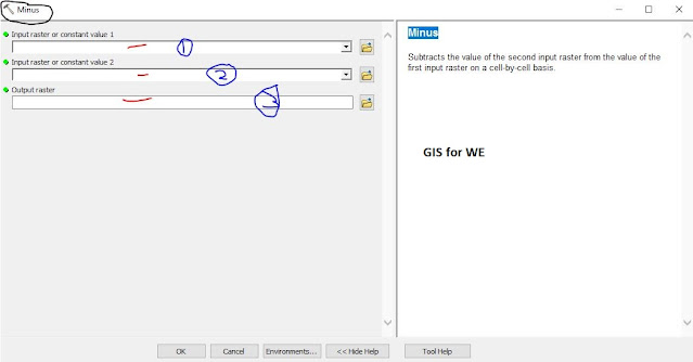
Minus
How to use Minus Tool in ArcToolbox ArcMap ArcGIS ??
 |
| Minus Tool |
Minus Tool, Raster Math Toolset, 3D Analyst Toolbox
Minus
Subtracts the value of
the second input raster from the value of the first input raster on a cell-by-cell
basis.
1. Input raster or constant value 1
The input from which to
subtract the values in the second input.
A number can be used as
an input for this parameter, provided a raster is specified for the other
parameter. To be able to specify a number for both inputs, the cell size and
extent must first be set in the environment.
2. Input raster or constant value 2
The input values to
subtract from the values in the first input.
A number can be used as
an input for this parameter, provided a raster is specified for the other
parameter. To be able to specify a number for both inputs, the cell size and
extent must first be set in the environment.
3. Output raster
The output raster.
The cell values are the
result of subtracting the second input from the first.
Plus
How to use Plus Tool in ArcToolbox ArcMap ArcGIS ??
 |
| Plus Tool |
Plus Tool, Raster Math Toolset, 3D Analyst Toolbox
Plus
Adds (sums) the values
of two rasters on a cell-by-cell basis.
1. Input raster or constant value 1
The input whose values
will be added to.
A number can be used as
an input for this parameter, provided a raster is specified for the other
parameter. To be able to specify a number for both inputs, the cell size and
extent must first be set in the environment.
2. Input raster or constant value 2
The input whose values
will be added to the first input.
A number can be used as
an input for this parameter, provided a raster is specified for the other
parameter. To be able to specify a number for both inputs, the cell size and
extent must first be set in the environment.
3. Output raster
The output raster.
The cell values are the
sum of the first input added to the second.
Times
How to use Times Tool in ArcToolbox ArcMap ArcGIS ??
 |
| Times Tool |
Times Tool, Raster Math Toolset, 3D Analyst Toolbox
Times
Multiplies the values of
two rasters on a cell-by-cell basis.
1. Input raster or constant value 1
The input containing the
values to be multiplied.
A number can be used as
an input for this parameter, provided a raster is specified for the other
parameter. To be able to specify a number for both inputs, the cell size and
extent must first be set in the environment.
2. Input raster or constant value 2
The input containing the
values by which the first input will be multiplied.
A number can be used as
an input for this parameter, provided a raster is specified for the other
parameter. To be able to specify a number for both inputs, the cell size and
extent must first be set in the environment.
3. Output raster
The output raster.
The cell values are the product of the first input multiplied by the second.

Comments
Post a Comment